Īxiptli:Hurricane Jova Oct 10 2011 1740Z.jpg

Tamaño de esta previsualización: 600 × 600 pixels. Otras resoluciones: 240 × 240 pixels | 480 × 480 pixels | 768 × 768 pixels | 1024 × 1024 pixels | 2048 × 2048 pixels | 5760 × 5760 pixels.
Tzintiliztlahcuilolli (5760 × 5760 pixel; tlaixiptlayotl octacayotl: 4,18 MB; machiyotl MIME: image/jpeg)
Tlacecempohualoni
| Tlacemmelahualiztli |
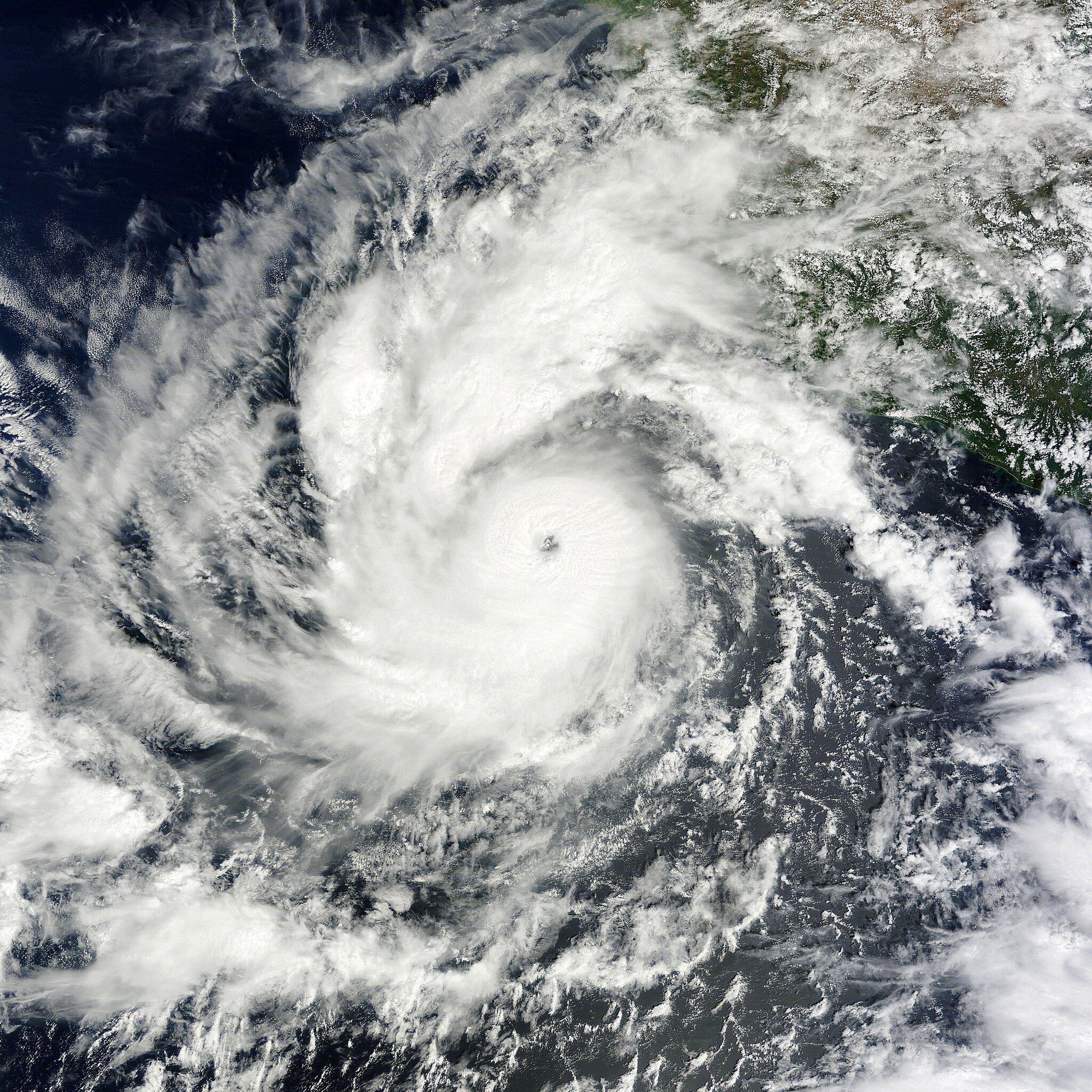
English: On October 6, 2011, a tropical depression over the eastern Pacific Ocean strengthened into Tropical Storm Jova. On October 8, it became a hurricane. By 11:00 a.m. Pacific Daylight Time (PDT) on October 10, 2011, the U.S. National Hurricane Center (NHC) reported that Jova was a Category 3 storm headed for the southwestern coast of Mexico.
The Moderate Resolution Imaging Spectroradiometer (MODIS) on NASA’s Terra satellite captured this natural-color image at 10:40 a.m. Pacific Daylight Time on October 10, 2011. Jova sports the spiral shape and distinct eye characteristic of strong storms. In the northeast quadrant, the storm’s clouds graze the coast of Mexico. As of 11:00 a.m. PDT on October 10, Jova had maximum sustained winds of 125 miles (205 kilometers) per hour, and was located roughly 220 miles (255 kilometers) southwest of Manzanillo, Mexico. A hurricane warning was in effect from Punta San Telmo north to Cabo Corrientes, and a tropical storm warning was in effect for Lazaro Cardenas north to Punta San Telmo. The NHC stated that the storm could become a Category 4 hurricane before making landfall on October 11. |
| Mactli | |
| Tzintiliztli | http://earthobservatory.nasa.gov/NaturalHazards/view.php?id=73873 |
| Autor | NASA image courtesy MODIS Rapid Response Team, Goddard Space Flight Center. Caption by Michon Scott. |
Licencia
| Este archivo es de dominio público porque fue creado por la NASA. Las políticas sobre copyright de la NASA estipulan que «el material de la NASA no está protegido con copyright a menos que se indique lo contrario». (Políticas sobre copyright de la NASA o Políticas sobre la utilización de imágenes del Jet Propulsion Laboratory). | ||
 |
Advertencias:
|
Amatl itlatolol
Haz clic sobre una fecha y hora para ver el archivo tal como apareció en ese momento.
| Tonallapohualpan ihuan imman | Pilixkopintsin | Octacayotl | Tekitiketl | TlahtoIcaquiliztiloni | |
|---|---|---|---|---|---|
| naman | 21:45 6 Cēn 2019 | | 5760 × 5760 (4,18 MB) | David Levy | cropped |
| 20:59 10 Mahtlāc 2011 |  | 5760 × 6000 (4,67 MB) | Supportstorm | {{Information |Description ={{en|1=Hurricane Jova on October 10, 2011}} |Source =http://lance-modis.eosdis.nasa.gov/wms/?zoom=5&lat=19.20117&lon=-105.74414&layers=B0000FFFFFFT&datum1=10/10/2011 |Author =NASA, MODIS Rapid Response System |
In canin oquitlalihqueh
Ahmo oncah tlahcuiloliztli tlein quitzonhuilia nican.
can nohuiyanyoh motequipanoh inin tlachiyaliztecpaliztli
Las wikis siguientes utilizan este archivo:
- Uso en de.wikipedia.org
- Uso en en.wikipedia.org
- Uso en ko.wikipedia.org
- Uso en zh.wikipedia.org