Īxiptli:Earth Western Hemisphere.jpg
Tzintiliztlahcuilolli(2048 × 2048 pixel; tlaixiptlayotl octacayotl: 579 kB; machiyotl MIME: image/jpeg)

Este archivo es de Wikimedia Commons y puede usarse en otros proyectos. La descripción en su página de descripción del archivo se muestra debajo.

Tlacecempohualoni

Tlacemmelahualiztli
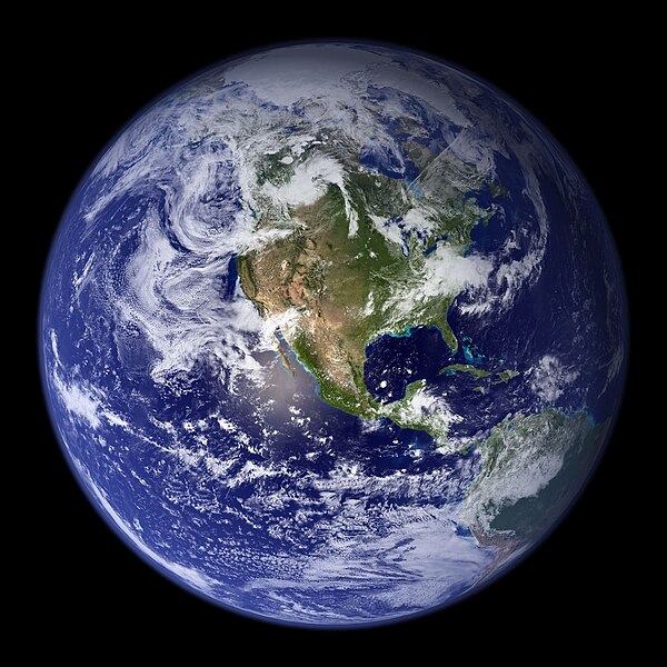
English: “Blue Marble”. Original caption:
Much of the information contained in this image came from a single remote-sensing device-NASA’s Moderate Resolution Imaging Spectroradiometer, or MODIS. Flying over 700 km above the Earth onboard the Terra satellite, MODIS provides an integrated tool for observing a variety of terrestrial, oceanic, and atmospheric features of the Earth. The land and coastal ocean portions of these images are based on surface observations collected from June through September 2001 and combined, or composited, every eight days to compensate for clouds that might block the sensor’s view of the surface on any single day. Two different types of ocean data were used in these images: shallow water true color data, and global ocean color (or chlorophyll) data. Topographic shading is based on the GTOPO 30 elevation dataset compiled by the U.S. Geological Survey’s EROS Data Center. MODIS observations of polar sea ice were combined with observations of Antarctica made by the National Oceanic and Atmospheric Administration’s AVHRR sensor—the Advanced Very High Resolution Radiometer. The cloud image is a composite of two days of imagery collected in visible light wavelengths and a third day of thermal infra-red imagery over the poles. Global city lights, derived from 9 months of observations from the Defense Meteorological Satellite Program, are superimposed on a darkened land surface map.
Mactli
Tzintiliztli http://visibleearth.nasa.gov/view.php?id=57723
Autor
  • Reto Stöckli (land surface, shallow water, clouds)
  • Robert Simmon (enhancements: ocean color, compositing, 3D globes, animation)
  • Data and technical support: MODIS Land Group; MODIS Science Data Support Team; MODIS Atmosphere Group; MODIS Ocean Group
  • Additional data: USGS EROS Data Center (topography); USGS Terrestrial Remote Sensing Flagstaff Field Center (Antarctica); Defense Meteorological Satellite Program (city lights).
Otras versiones Derivative works of this file:  Environment Barnstar new.png

Licencia

Public domain Este archivo es de dominio público porque fue creado por la NASA. Las políticas sobre copyright de la NASA estipulan que «el material de la NASA no está protegido con copyright a menos que se indique lo contrario». (Políticas sobre copyright de la NASA o Políticas sobre la utilización de imágenes del Jet Propulsion Laboratory).
Advertencias:
  • El uso del logotipo de la NASA (incluidos el logotipo actual y los anteriores) está restringido.
  • El sitio web de la NASA almacena una gran cantidad de imágenes del Programa Espacial de la URSS, de la Agencia Espacial Federal Rusa y otras agencias espaciales no estadounidenses. Estas imágenes no son de dominio público.
  • Material del Telescopio espacial Hubble puede tener copyright si no proviene explícitamente del Space Telescope Science Institute. [1]
  • Todo el material creado por la sonda espacial SOHO está protegido por copyright y requiere permiso para ser utilizado con fines comerciales o no educativos. [2]
  • Las imágenes que figuran en el sitio web Astronomy Picture of the Day (APOD) pueden tener copyright. [3]

Leyendas

Añade una explicación corta acerca de lo que representa este archivo

Elementos representados en este archivo

representa a español

No existe ningún valor para esta propiedad

tipo de archivo español

image/jpeg

Amatl itlatolol

Haz clic sobre una fecha y hora para ver el archivo tal como apareció en ese momento.

Tonallapohualpan ihuan immanPilixkopintsinOctacayotlTekitiketlTlahtoIcaquiliztiloni
naman03:09 25 Aho 2005Miniatura de la versión del 03:09 25 Aho 20052048 × 2048 (579 kB)Tom{{PD-USGov-NASA}} http://earthobservatory.nasa.gov/Newsroom/BlueMarble/Images/globe_west_2048.jpg Much of the information contained in this image came from a single remote-sensing device-NASA’s Moderate Resolution Imaging Spectroradiometer, or MODIS.

Ahmo oncah tlahcuiloliztli tlein quitzonhuilia nican.

can nohuiyanyoh motequipanoh inin tlachiyaliztecpaliztli

Las wikis siguientes utilizan este archivo:

Ver más uso global de este archivo.